Our World
Australia – Europe Size Comparison


Many would have seen videos on “The Road to Death in Bolivia before, however I really like what Free Documentary have done to go into more details about “The Road to Death” in this documentary version, if you like this video, please checkout their YouTube Channel for more of these and more videos, they have an awesome channel.
Quoting below from their description of this video
“The Carretera de la muerte – the road to death- is one of the most dangerous roads in the world. Year after year many people die here. We accompany trucker Omar and his co-driver Jaime on their trip across the Andes, encountering cyclists, mountain bikers and coca-farmers on the way.”
Our World
The amazing Faroe Islands
In a world of amazing places, the Faroe Islands have to rank up there with the most amazing ….
10 Years ago I stumbled across photos of very interesting looking islands. On further investigation I found that these were the Faroe Islands and that they lie north, north west of the UK approximately 300km from the top end of Scotland and between the North Atlantic Ocean and the Norwegian Sea. We posted about the Faroe Islands back then and the story was very popular, So popular that we have decided to reprise the post with some new and larger images and hope that a new audience may like these images and the story. All of the photos are by Olavur Frederiksen and we are extremely thankful for Olavur’s permission to use these photos. I highly recommend that you visit his website links at the end of this story to see more of his work. TO SEE MANY MORE PHOTOS HERE, SCROLL THIS POST..
Klaksvik, second largest town in the Faroes and located on island of Bordoy

Photo: Olavur Frederiksen @ https://www.facebook.com/faroephoto/
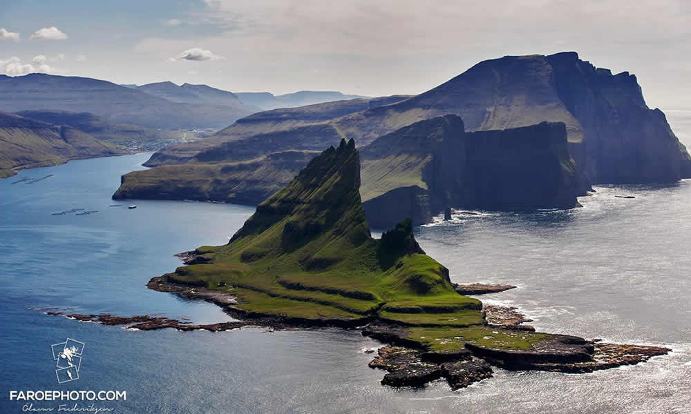
Gáshólmur and Tindhólmur

Photo: Olavur Frederiksen @ https://www.facebook.com/faroephoto/
More Information on the Faroe Islands
History of The Faroe Islands
Not much is known of the earliest history of the islands, Irish hermits (monks) settled on the islands in the sixth century, bringing with them sheep and oats as well as early Irish language.
Around 650 AD the Vikings replaced the Irish, bringing with them the Old Norse language, which has evolved into the currently spoken (Faroese) language which is spoken today. These viking settlers came from Norwegian settlements in Shetland, Orkney and islands in the Irish Sea.
Norwegian control of the Islands continued until 1380, when Norway entered into the Kalmar Union with Denmark and control gradually transferred to Denmark. When this union between Norway and Denmark was dissolved as a result of the Kiel Treaty in 1814, Denmark retained control of the Faroe Islands.
During World War 2 the British army occupied the islands so as to strengthen control of the North Atlantic, however after the war control reverted back to Denmark and a home-rule regime was implemented granting a high degree of local autonomy.
So where in the world are The Faroe Islands

Image: Google Earth
18 main islands make up the Faroes

Image: Wikipedia
Economy
“The Faroes declined to join Denmark in entering the European Community (now European Union) in 1973. The islands experienced considerable economic difficulties following the collapse of the fishing industry in the early 1990s, but have since made efforts to diversify the economy. Support for independence has grown and is the objective of the government.”
The Faroe Islands’ Unemployment levels have come back in the last few years, with unemployment down to 5% in mid-1998. By June 2008 unemployment had declined to 1.1%, before rising to 3.2% in December 2014, although this is still among the lowest in Europe. Nevertheless, the almost total dependence on fishing means that the economy remains extremely vulnerable. The current fishing catch landed in the Faroe Islands are either exported fresh or processed into fresh fillets, frozen fillets or wet salted fish. Other species are processed into fish meal and oil, or feed for the fish farms. The primary export markets are Denmark (shrimp), Great Britain (Cod and haddock), Germany, France (coly, redfish, black halibut), the Mediterranean countries (salted fish), USA (frozen cod and haddock) and Japan (shrimps, trout).
Petroleum reserves
In 2014 the United Nations Commission recognized the claimed entitlement of the Faroe Islands to local oil reserves, which means that the Faroes will be allocated at least 27,000 km² of the shelf north of the Faroe Islands, of which the Faroes will have the sovereign right to exploration of resources both on the seabed and the underground.
Source: faroeislands.fo
Information Technology
Since 2000, new information technology and business projects have also been fostered in the Faroe Islands to attract new investment.

Photo: Olavur Frederiksen @ https://www.facebook.com/faroephoto/

Photo: Olavur Frederiksen @ https://www.facebook.com/faroephoto/
Climate
As discussed above the Faroe Islands are approx 350 km north north west of the top end of Scotland, making them not far from the southern end of the Arctic Circle. Considering their high latitude the islands are not as cold as you might expect, with average temperatures of 3 degrees Celsius in winter and 11 degrees Celsius in summer. That said the Islands are covered in much snow during the colder months, as can be seen in the above photos, This snow then forms a melt and plenty of water for the growth of the plentiful green grass all over the islands, which can be seen in many of the other photos.
Litla-Dimun, the only uninhabited island of the Faroe Islands

Photo: Olavur Frederiksen @ https://www.facebook.com/faroephoto/
Geography
The Faroe Islands consist of eighteen separate islands. The whole area of the Islands is approximately 1399 square km (540 sq Mles). There is 1117 kilometes (694 mi) of coastline. There are no land boundaries with any other country. The only island that is uninhabited is Lítla Dímun.
“The Islands are rugged and are dominated by tholeiitic basalt lava which was part of the great Thulean Plateau during the Paleogene period.”
Gásadalur, located on the west-side of Vágar Island

Photo: Olavur Frederiksen @ https://www.facebook.com/faroephoto/
Mykines Lighthouse

Photo: Olavur Frederiksen @ https://www.facebook.com/faroephoto/
Transportation
“Vágar Airport has scheduled service to destinations from Vágoy Island. The largest Faroese airline is Atlantic Airways.Due to the rocky terrain and relatively small size of the Faroe Islands, its transportation system was not as extensive as other places of the world. This situation has changed, and today the infrastructure has been developed extensively. Some 80% of the population in the islands is connected by under-ocean tunnels, bridges, and causeways which bind the three largest islands and three other large islands to the northeast together.”

Photo: Olavur Frederiksen @ https://www.facebook.com/faroephoto/
Torshavn Harbour

Photo: Olavur Frederiksen @ https://www.facebook.com/faroephoto/
Aurora over Tórshavn

Photo: Olavur Frederiksen @ https://www.facebook.com/faroephoto/
One final thing, I have made myself a promise that I will travel to the Faroe Islands sometime in the future, It’s such and incredible looking place and I am really looking forward to some helicopter rides around the islands. Credits I must thank Olavur Frederiksen of Faroe Photo for allowing me to use some of his amazing collection of photos. Please see his website link below if you are interested, he has many more wonderful photos. The Faroe Photo Site has a shop which allows you to purchase 150 Impressions of the Faroes Islands. Olavur Frederiksen @ Faroe Photo All other information for this post was obtained via Wikipedia.
Photo: Olavur Frederiksen @ https://www.facebook.com/faroephoto/Traditional grass covered roofs

Photo: Olavur Frederiksen @ https://www.facebook.com/faroephoto/Pilot Whales

Photo: Olavur Frederiksen @ https://www.facebook.com/faroephoto/Klaksvík, second largest town in Faroe and on the Island of Bordoy

Photo: Olavur Frederiksen @ https://www.facebook.com/faroephoto/Tindhólmur
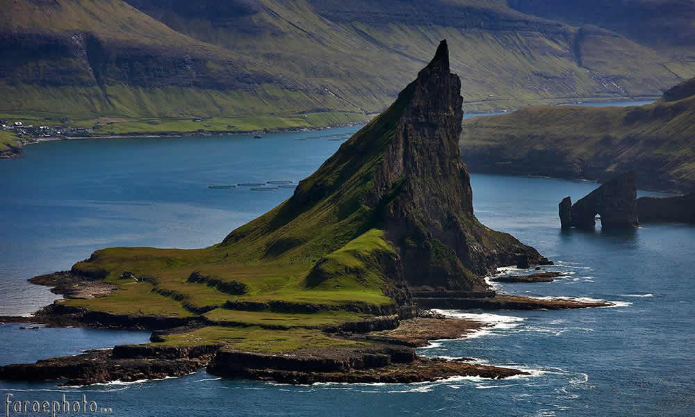
Photo: Olavur Frederiksen @ https://www.facebook.com/faroephoto/Tindhólmur

Photo: Olavur Frederiksen @ https://www.facebook.com/faroephoto/

Some refer to this place as the most isolated house in the World and given it’s location off the coast of Iceland, I guess they’d be not far wrong, The Island is called Elliðaey, or Ellirey if you don’t have the Icelandic lingo down pat.
So just where is Elliðaey Island ?

Map showing Elliðaey Island’s location off the South West Coast of Iceland
A bit of the History Elliðaey Island
Three hundred years ago, Elliðaey was inhabited by five families. They lived there in huts and survived by fishing and raising cattle on the island’s grassy pasture — and by hunting puffins. By the 1930’s though, the last of these inhabitants left the island, and it remained largely uninhabited until 1953, when the Elliðaey Hunting Association built a lodge for it’s members to use whilst they were visiting for hunting Puffins on the island.
Below are some more stunning photos of Elliðaey Island.


Image: Diego Delso, CC BY-SA 4.0, https://commons.wikimedia.org/w/index.php?curid=37347785

Free Documentary: Road to Death Bolivia

Fairytale of New York by The Pogues and Kirsty MacColl

Dating Advice Aussie Style from Paul Hogan

The Most Damn Parrot in the World

Alex Dyson, Independent for Wannon launches policies via Interpretive Dance


-

 Our World6 years ago
The amazing Faroe Islands
-

 Humour13 years ago
Wife comes home after a night out with the girls
-

 Our World6 years ago
Secluded house on a far away island
-

 Construction6 years ago
Amazing Airport Runway in Portugal
-

 Culture5 years ago
A look into the future from 1930’s Soviet Russia
-

 Construction6 years ago
Hong Kong Zhuhai Macau Bridge opens in China